 |
|||
|
|
|||
       |
Special Feature on Technical Solutions to Real-world Problems Vol. 7, No. 9, pp. 11–13, Sept. 2009. https://doi.org/10.53829/ntr200909sf4 Improved Cable-height Measuring EquipmentAbstractNTT EAST has developed equipment that enables simple and efficient cable-height testing to prevent accidents due to cables running at insufficient heights above the ground. This article outlines this new cable-height measuring equipment, which is now being deployed in several prefectures in Japan. 
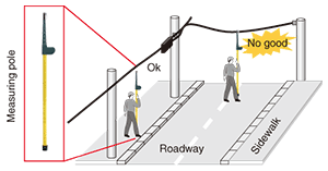
1. Conventional cable-height measurementThe collapse of a street lamp in Yokohama City in November 2006 prompted emergency testing for insufficient cable heights and ongoing correction of faulty facilities. NTT EAST places great importance on surveying the height of aerial cables that cross roadways to ensure the reliability of its facilities, and it corrects cable facilities that are found to run at insufficient heights. Although aerial cables are initially installed at an appropriate height, they can sag for various reasons, so periodic inspections are necessary. These inspections have traditionally been performed manually at each target location using a measuring pole. Cable-height measurements have consequently required a huge amount of time and labor as well as human risk for tests performed at dangerous sites like roadways (Fig. 1).
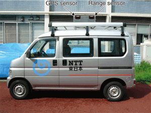
2. New cable-height measuring equipmentThe newly developed equipment consists of a measurement vehicle with a ranging sensor and a GPS (global positioning system) sensor mounted on its roof (Fig. 2). With these sensors, the equipment can automatically measure cable height as the vehicle moves along while simultaneously obtaining location information (latitude and longitude). It can also record the results in a cartographic database.
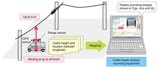
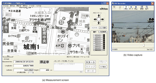
This equipment performs safe and accurate measurements using ultrasonic waves while the vehicle is travelling at up to 40 km/h and it can measure road-crossing cables having heights of up to 5 m. Measurement results are automatically mapped to a digital map and recorded together with video images taken while the vehicle is moving. Once measurements have been taken, route display, data searching, and other functions are available if desired (Fig. 3). Some examples of screenshots taken inside the vehicle are shown in Fig. 4.
The measurement screen displays measurement time, longitude, latitude, and height in the lower left and marks the route taken by the vehicle on a digital map. As shown in Fig. 4(a), the map includes both green circles (shown in white here) and red circles (dark). A green circle indicates that the height requirements are satisfied while a red circle indicates a location where an aerial cable does not satisfy the height requirements. However, as the heights of other objects besides aerial cables (such as trees) are also displayed, the vehicle is equipped with a video camera to enable workers to determine whether the object in question is actually an aerial cable (Fig. 4(b)). The images shown in Figs. 4(a) and (b) are displayed on a liquid crystal display (similar to a personal computer screen). They can also be referred to back in the office to check for locations where cable heights are insufficient. 3. Future plansDevelopment of the cable-height measuring equipment introduced here has been completed with the aim of achieving efficient discovery of aerial cables running at insufficient heights. NTT EAST is moving forward with the deployment of this equipment in all the prefectures that it covers with the conviction that it will contribute greatly to the provision of safe, secure, and reliable facilities. |
||