 |
|||||||||||||||||||
|
|
|||||||||||||||||||
       |
Special Feature: Disaster Prevention and Management Solutions for Better Comprehensive Disaster Resilience Vol. 8, No. 12, pp. 17–21, Dec. 2010. https://doi.org/10.53829/ntr201012sf2 Realtime Disaster Response Using Satellites and Positioning InformationAbstractWe aim to develop an effective disaster response solution using satellites and positioning information. It will provide users with context-sensitive action menus according to their location and situation by sending messages from satellites to GPS (global positioning system) receiver terminals such as cell phones and car navigation systems during disasters. Application experiments based on industry-government-academia collaboration using the first quasi-zenith satellite, which was launched in September 2010, are planned. We also aim at international expansion of the results. 
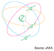
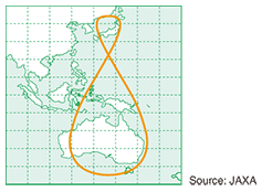
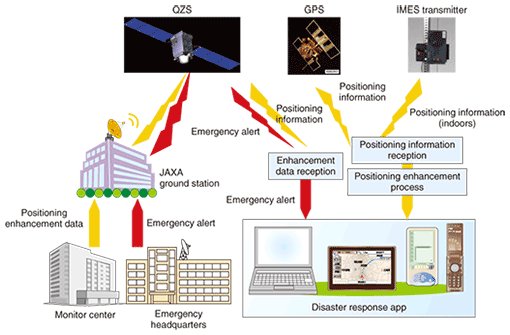
1. IntroductionWe aim to develop a realtime disaster response solution using space technologies, which are not vulnerable to terrestrial disasters, to enable people to get necessary information anytime, anywhere during disasters. Japan’s first self-developed positioning satellite, Michibiki [1], which was prepared and is being operated by JAXA (Japan Aerospace Exploration Agency), was successfully launched on September 11, 2010. It is called a quasi-zenith satellite (QZS) because if the quasi-zenith satellites system (QZSS) is operated with at least three satellites, then one satellite always appears near the zenith above Japan. QZSS orbits are shown in Figs. 1 and 2. The QZSS orbital period is the same as for geostationary satellites with some orbital inclinations. The QZSS is designed to enhance the availability and performance of the global positioning system (GPS) operated by the USA. For availability enhancement, a QZS at high elevation angles can send signals to receivers even if they are in mountainous terrain or urban canyons. It achieves higher accuracy because of the wider coverage of positioning services. For performance enhancement, QZS has the capability to broadcast performance enhancement signals including an L1-SAIF (submeter-class augmentation with integrity function) signal. This signal mainly carries low-volume data for performance enhancement but can also be used for emergency messages. It can be received directly from the satellite by GPS receiver terminals such as cell phones and car navigation systems. We identified two advantages of using this signal for realtime disaster response: popular GPS terminals with location information can be used in an emergency and they can receive data even when the terrestrial communications infrastructure is damaged by the disaster.
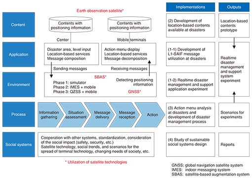
2. Positioning information in disaster responseA realtime disaster response requires cooperative work between the emergency headquarters and disaster sites involving a huge amount of information in various situations. For wide-area disasters in particular, accurate information gathering and decision making are needed for a realtime disaster response according to the changing situation. The location information used in a geographical information system is of key importance in aggregating information about dispersed victims. Moreover, the cooperative work must be conducted under various constraints. For example, people might not use the communication infrastructure as usual and they might also have to accompany old people and children who are unfamiliar with information technology. In such situations, it will be helpful if we provide context-sensitive action menus for the people at disasters by utilizing their location information. It will make the initial response to the disaster faster and more efficient at avoiding chaos. This solution enables the emergency headquarters to collect photographs at disaster sites by asking people to take pictures at specific locations if possible. 3. Red Rescue ProjectThe Red Rescue Project (for realtime disaster response using small-capacity data packets from the ubiquitous environment) is supported by the fund for promoting space technology utilization of the Ministry of Education, Culture, Sports, Science and Technology. It started in 2009 as a three-year project. The project leader is NTT DATA and the other project members are Keio University, Asia Air Survey, and Pasco. We are engaged in the activities shown in Fig. 3. The project is open to SPAC (Satellite Positioning Research and Application Center) committee members of the disaster response application team. Expert meetings were held to discuss the disaster response solution. By establishing a disaster response solution using Japan’s QZS, this project represents industry-academia-government collaboration with high social impact and publicity.
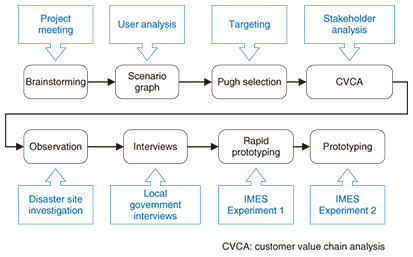
One of the unique features of this project is the introduction of a system design management method to clarify the system requirements. We analyzed the requirements by various methods from the viewpoints of the various involved parties (stakeholders) and made prototypes before the real-environment experiment. The project flow chart in 2009 is shown in Fig. 4; it includes brainstorming, scenario analysis (scenario graph, Pugh selection), customer value chain analysis, observation and interviews (survey of local governments recently damaged by natural disasters), and prototyping. We have openly discussed the results in order to pursue socially sustainable system design with external experts in expert meetings and in academic conferences [2], [3].
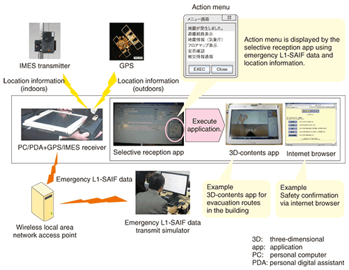
4. Experimental environmentIn the first year of the project, before the satellite launch, there were no QZSs available, so we established an indoor messaging system environment (IMES), at Keio University (Kyoseikan in Hiyoshi) and made a prototyping system with an L1-SAIF data simulator for disaster response. There are some constraints on using the L1-SAIF signal. (1) Low data volume (212 bits) and slow data rate (250 bit/s) (2) Limited usage (We assumed that only 10% of the total transmission capacity would be available for disaster response.) (3) Data redundancy because data is broadcast (4) Data loss due to burst errors The technical issues are how to utilize low-volume broadcast data like L1-SAIF messages. We implemented the following. (1) Data compression method using master data and parameters (2) Selective reception algorithm using coding location information (3) Transaction method for indexing multiple data messages (4) Action menus suggesting appropriate actions to the receivers using location information and alert messages The IMES experimental flow, shown Fig. 5, includes selective reception and application execution using action menus. In this experiment, we used three-dimensional contents. At times when the communication infrastructure is unavailable, we expect to use local content like maps in car navigation systems.
5. Future plansTechnical experiments were scheduled to begin soon after the launch of the first QZS, Michibiki, in September 2010 and the application experiments will start in early 2011. The Red Rescue Project has an experimental plan for the environment, as shown in Fig. 6, involving collaboration with the government’s experimental plan [4].
QZSS needs at least three satellites so that one satellite always appears near the zenith above Japan. The results of the technical and application experiments will therefore be important in future planning decision making. Application development plans for not only a realtime disaster response solution but also for high-accuracy land surveys, information-technology-based agriculture, and so on have been proposed. We are proceeding with the project through industry-academia-government collaboration to establish a happy, secure, convenient Japanese society using the merits of the QZSS. In the future, it will be important to connect related systems in Japan such as J-ALERT and NTT DOCOMO’s Area Mail. Taking advantage of opportunities such as Multi-GNSS Asia (GNSS: global navigation satellite systems) [5], [6], we will discuss future collaboration with countries that have positioning satellites such as the USA, Russia, Europe, China, and India. Furthermore, we hope to promote the standardization of solutions. References
|
||||||||||||||||||