 |
|||||||||||
|
|
|||||||||||
|
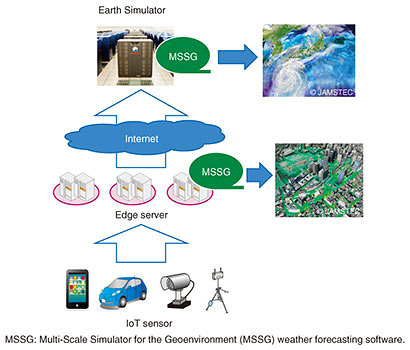
Feature Articles: Research and Development Initiatives for Internet of Things Implementation Vol. 16, No. 9, pp. 28–32, Sept. 2018. https://doi.org/10.53829/ntr201809fa5 Utilization of Edge Computing and IoT Sensors in Hierarchical Weather Forecasting SystemAbstractNTT and the Japan Agency for Marine-Earth Science and Technology (JAMSTEC) began collaborative research on a hierarchical weather simulation system using the Earth Simulator and edge computing in 2016. This project promotes the creation of new technology for the interworking of geographically distributed Internet of Things (IoT) sensors, regionally located edge computing, and the Earth Simulator that is capable of large-scale weather simulation. The project also promotes the development of fundamental technology for supporting various IoT services. Keywords: edge computing, IoT sensors, hierarchical weather simulation  1. IntroductionThe Internet of Things (IoT) has been attracting attention because it connects all kinds of things to the Internet and makes various kinds of sensing possible. The future IoT society is expected to bring innovation in various industries by enabling the collection and analysis of a variety of sensor data via a network independently of time, place, or environment. While some IoT sensors such as thermometers transmit low-volume data, others produce large-volume data such as still-image or video data from infrared cameras. The sensing frequency and the number of sensors installed also vary with the service provided. From the viewpoint of using sensor data in services, some data are used only regionally, and other data are aggregated for analysis on a national scale in the cloud. One use case that requires such aggregation of data that has different regional dispersion requirements is weather forecasting. 2. Weather forecasting simulation using IoT dataWeather forecasting is an important key in the construction of the IoT society. Highly accurate real-time weather forecast data are expected to be useful in many fields. In addition to obvious applications in the primary industries of agriculture and fishing, applications in the areas of automobile and rail transportation and sports stadium industries are also expected. A simple way to increase the accuracy of weather forecasting is to increase the resolution of the model. In simulations such as weather forecasting models, the target spatial region is divided into a constant-interval grid, and calculations for each unit of the grid are done according to relationships with the neighboring units. A grid that has smaller units enables a higher-resolution simulation that closely models the behavior of the actual environment, but there is a trade-off between grid resolution and computational load. For example, for a simulation in three-dimensional space, reducing the length of a grid unit by one-half increases the amount of grid calculation by a factor of eight (two to the third power). It is also necessary to reduce the time interval for the calculations by half, so the total computational cost increases by a factor of 16 (two to the fourth power). Therefore, highly accurate prediction for all locations in the space requires a huge amount of calculation. However, it is not necessary to make highly accurate predictions in all locations. For predictions relevant to the agricultural industry, for example, it is sufficient to cover agricultural land areas, and for automotive transportation, it is sufficient to cover expressways and national highways. If it were possible to achieve highly accurate local weather forecasting simulations in addition to the conventional large-area simulations, it would be possible to provide sufficient weather forecasting at low cost. Conventional large-area weather forecasting simulations are based on data for large regions; such data may consist of atmospheric pressure distributions and weather satellite images. For local weather forecasting, local on-site data are input to the simulation in real time. It is possible to provide highly accurate local weather forecasts by using IoT sensor data such as local sky images and data from local temperature sensors. Furthermore, the highly accurate local weather forecasting data can be used to improve the accuracy of regional simulations. NTT and the Japan Agency for Marine-Earth Science and Technology (JAMSTEC) [1] began collaborative research on a hierarchical weather simulation system using the supercomputer Earth Simulator*1 and edge computing*2 in 2016 [2]. The collaborative research reported here involves construction of a hierarchical weather simulation system that looks toward a future IoT platform by combining IoT sensors, edge servers that serve as specialized regional computing resources, and a large-scale Earth Simulator computing system. We are using that system to test the effect of IoT sensor data in local weather simulations and will continue to work on identifying and solving problems of the system as an IoT platform [3].
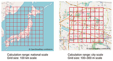
3. Hierarchical weather simulation systemThe hierarchical weather simulation system (Fig. 1) combines IoT sensors, edge servers that aggregate the data from the sensors, and the Earth Simulator supercomputer—all types of equipment that have different specifications and functions—in a multilevel configuration. The hierarchical weather simulation system is run on the Multi-Scale Simulator for the Geoenvironment (MSSG) weather forecasting software developed by JAMSTEC. MSSG is capable of running weather forecasting simulations on various geographical scales (Fig. 2). The specified calculation range is divided into a grid, and the units of the grid serve as units for simulation of temperature, humidity, atmospheric pressure, wind direction, wind speed, sunshine, and precipitation. The grid unit can be set according to the computational resources that are available. If the grid is made smaller for the same amount of computational resources, the simulation is performed on a local scale, and if a larger unit is used, the simulation is run on a regional scale.
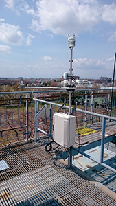
Another major feature of MSSG is the data assimilation function, which makes it possible to integrate observation data into the simulation results. The accuracy of prediction by simulation can be improved by inputting observation data within the range of the simulation. Specifically, temperature, wind direction, and other weather data can be assimilated, and in addition, sky image data can also currently be used by MSSG. In the future, it will also be possible to use the assimilation function for a wide variety of data acquired by IoT sensors in weather forecasting. Next, we consider the role of the hardware in each level of the hierarchical weather simulation system. The top-level Earth Simulator is a supercomputer operated by JAMSTEC and is used for large-scale computations that are required for marine and Earth science research in areas such as global warming and geological changes. MSSG runs on the Earth Simulator and divides the entire globe into a grid that has units of about 10 km for weather forecasting simulations. The edge servers that constitute the hardware for the middle level of the system are distributed over each region. It is assumed that the edge servers will be located near users within NTT’s wired network and mobile network base stations in the future. In our joint research, the edge servers run MSSG in the same way as does the Earth Simulator. For the MSSG on the edge servers, the calculation range is narrowed to a grid unit size of several hundred meters to effectively use the computational resources in performing a local weather simulation. The IoT sensors used for the bottom level are weather observation sensors, which measure basic weather data including temperature, humidity, precipitation, sunshine, wind direction, and wind speed at fixed time intervals and send the data to the edge servers (Fig. 3).
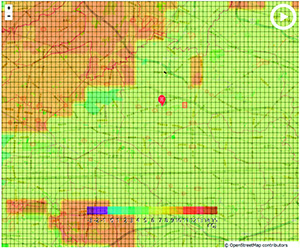
In the hierarchical weather simulation, data are assimilated and exchanged between adjacent levels in the hierarchy. The IoT sensors send data to the edge servers, which assimilate the data and run highly accurate local weather forecasting simulations. The edge servers exchange simulation results with the Earth Simulator. The local weather simulations can obtain boundary conditions for the margins of their calculation ranges by obtaining weather information outside their computation range from the regional weather simulations. The wide-area weather simulations can obtain the highly accurate weather simulation information from particular regions. After the accuracy of wide-area simulations is improved by assimilating data from the results of local simulations, data from the improved wide-area forecast results can be assimilated back into the local simulations. The middle latitudes in which Japan is located are known for weather that changes from west to east due to westerly winds. Wide-area simulations can use data assimilated from local simulations to good effect with respect to such temporal changes. A nationwide distribution of IoT sensors and edge servers would make it possible to provide weather forecast data to locations of high business value such as dense population centers, areas in which primary industries are concentrated, riverine areas, national highways, and stadiums. 4. Effectiveness of hierarchical weather simulationWe used the hierarchical weather simulation system to conduct actual local weather forecasting simulations. The data from weather sensors and the results of wide-area simulation by the Earth Simulator were assimilated by edge servers. An example of the simulation results is shown in Fig. 4, which is a heatmap that shows the differences in temperature for the 300-m grid units of a local simulation for a sunny winter day, where we can see that there are temperature changes in each grid unit.
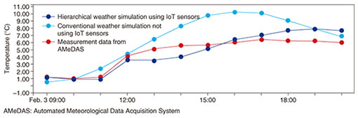
The temperature changes over time for the grid unit indicated by the red pin in Fig. 4 are plotted in the graph shown in Fig. 5, where dark blue data points are the forecast results for this hierarchical weather simulation, the light blue data points are the forecast results for a conventional simulation that does not use assimilation data from the sensors or from the Earth Simulator, and the red data points are actual data measurements (ground truth values) obtained by the Automated Meteorological Data Acquisition System (AMeDAS) operated by the Japan Meteorological Agency. We can see from the figure that using assimilation of the sensor data and data from the wide-area simulations results in forecast values that are close to the actual measured values.
5. Future prospectWe have described the principle of a hierarchical weather forecasting system that combines the Earth Simulator and edge computing. One problem for practical application of IoT in weather forecasting is installation of IoT sensors in non-ideal situations. Although the sensors used in the experiment reported here were installed in ideal environments, we cannot expect that all of the many IoT sensors used will be properly installed and maintained. To address this problem, we are investigating methods of determining sensor data reliability through a learning process based on past data to increase the value of IoT sensor data. We will also continue to explore generalized quantitative measures of the true value of an IoT platform for business by testing the effect of increasing the amount of measured data on the amount of sensor data and simulation results to determine how much value is generated with respect to the cost of installing edge computing resources. References
Trademark notesAll brand names, product names, and company names that appear in this article are trademarks or registered trademarks of their respective owners. |
|||||||||||