 |
|||
|
|
|||
       |
Feature Articles: Value Creation by Leveraging State-of-the-art Research Results Vol. 17, No. 2, pp. 43–49, Feb. 2019. https://doi.org/10.53829/ntr201902fa6 Improving Amenities at Narita International Airport—Utilizing High-precision Indoor Maps and Geomagnetic Positioning to Facilitate the Movement of VisitorsAbstractThe number of international visitors to Japan has been soaring. At Narita International Airport, the gateway to Japan, we aim to create airport services that allow everyone to spend time comfortably via the concept of a smart airport. In September 2018, a service called NariNAVI—Japan’s first high-precision indoor navigation application introduced at an airport—was launched. This application utilizes geomagnetic positioning as indoor-positioning technology. To display the map, we adopted a 2.5D (two-and-a-half-dimensional) map, which stereoscopically expresses spaces inside complex airport terminals spanning multiple floors. Providing such a map that is intuitive and user-friendly supports customers’ smooth movement inside the airport. Keywords: NariNAVI, geomagnetic positioning, 2.5D map
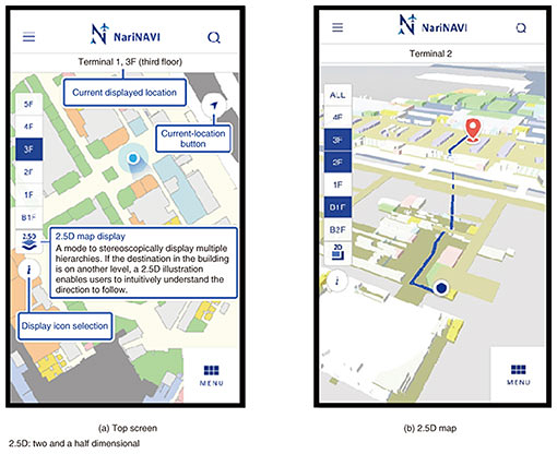
1. Current status and issues concerning Narita International AirportIn 2018, Narita International Airport (Narita Airport, hereafter) celebrated its 40th anniversary since starting operations. It is one of Japan’s busiest airports, so it is necessary to ensure that it is capable of handling the influx of visitors that continues to increase each year. 1.1 Increasing number of international visitorsIn anticipation of the international sports event being held in Japan in 2020, the country has made good progress in regard to national tourism policy. The number of inbound visitors has increased from 8.36 million in 2012 to 28.69 million in 2017, more than a threefold increase, and the government has set the target of 40 million visitors in 2020. Narita International Airport Co., Ltd. (NAA) has been promoting a three-year NAA Group medium-term management plan—Innovative Narita 2018—since 2016. This plan aims to retain and reinforce Narita’s position as a top-class international hub airport in Asia while striving to become an airport providing the world’s highest standard of quality and service for customers. By creating the world’s highest-level smart airport by utilizing state-of-the-art information and communication technology, NAA is striving to impress customers by providing them with exciting and unexpected experiences while setting the smart airport initiative as its aim to improve customer convenience and the overall comfort of Narita Airport. 1.2 Utility of high-precision indoor electronic mapThe space in an airport is vast. As well as acting as a transportation node for buses and railways, it functions as a complex commercial facility. People come from all over the world to visit Japan, and our experience tells us that the needs of those passengers are changing. For example, access to the city center, Wi-Fi service, and souvenir shops are just some of the needs to be met. We cannot respond to these diversified needs with only a simple unified map, so we therefore decided to create a high-precision indoor electronic map. Creating electronic mapping of existing buildings takes time and effort because the points where maps of indoor areas and outdoor areas connect differ depending on the map data sources, and there is no unified standard for map data. NAA prepared an electronic map in compliance with the guidelines created through the High Accuracy Positioning Society Project initiated by the Ministry of Land, Infrastructure, Transport and Tourism of Japan. In October 2017, we developed a form of digital signage called infotouch, which utilizes a high-precision map, and digitizing that map has made it possible to reflect changing terminal information in a timely manner. In addition, we introduced a mechanism for continuously displaying pictograms on the map of the facilities frequently used by customers (toilets, smoking areas, etc.) so that customers do not need to search for such facilities. Furthermore, the universal design approach was incorporated from scratch in various aspects of the designs of colors, buttons, and other details. We are installing four infotouch units in Terminal 1 and plan to expand the installation to cover all airport buildings by the end of fiscal 2019. As a new initiative, we simultaneously developed an application programming interface (API) that makes it possible to use high-precision electronic maps in other operations and by airline companies. We surmised that other businesses located at the airport would use the API to provide information displayed by infotouch on mobile devices and thereby improve customer convenience. By using location information in this manner, we can offer new ways to spend time at the airport. 1.3 Creation of NariNAVIDevelopment of the navigation application called NariNAVI (Fig. 1) started with the above-mentioned idea in mind. There are two important factors regarding information displayed via the application: the accuracy of the user’s position (self-location) and the ease of setting the destination. Various technologies are available for indoor positioning. We selected iBeacon since it is being adopted internationally as a mainstream technology for airport infrastructure. We installed about 1500 iBeacons at Narita Airport, and we combined the use of the iBeacons with geomagnetic positioning to determine location. Although installing the iBeacons in the proper position and height was difficult due to constraints such as passenger flow lines, we overcame that difficulty by reconsidering the typical geomagnetism survey method. It seems natural, but specifying a self-location indoors in places that GPS (Global Positioning System) cannot reach is actually quite groundbreaking.
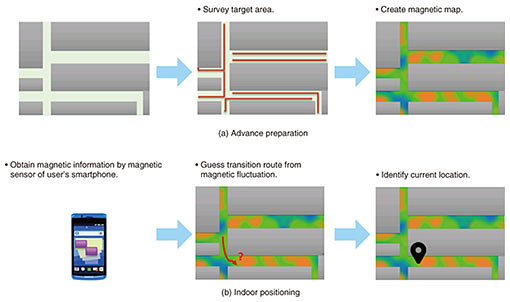
We implemented a predictive conversion function in the destination setting of NariNAVI. Although most search logics provided by facilities will ask for a search by formal name, we created a dictionary that also supports several variations so that users can search for a target facility without entering its official name. This feature makes it possible to search for flight information and shop facilities more easily. Another feature of NariNAVI is that it can be used with web browsers other than Android and iOS applications. It is displayable by web browsers, so it is easy to link with various web services via homepages. Moreover, by extending NariNAVI to robotics and chatbots (which are progressing in parallel with services based on location information), NAA wants to offer new services to everyone who uses Narita Airport. 2. Technology of NariNAVITwo NTT Group technologies were adopted in NariNAVI to accurately determine indoor location and intuitively represent maps in the complex layout of a multilevel airport. One is high-precision indoor-location technology using geomagnetism, and the other is two-and-a-half-dimensional (2.5D)-map platform technology. Geomagnetic positioning is a function of a cloud service called high-precision location information provided by NTT DATA, and it utilizes technology jointly developed by NTT DATA and GiPStech. The 2.5D-map platform technology was developed by NTT Service Evolution Laboratories and is used to express and transmit maps. NTT DATA is developing the NariNAVI application, and they have incorporated the above-mentioned technologies in the application. 2.1 High-precision indoor location-information serviceThe high-precision indoor location-information service provided by NTT DATA is a cloud service providing map distribution, indoor positioning, and route-search functions, which are basic functions for creating navigation services in indoor spaces. By using this service, customers who wish to create indoor guidance services can focus on developing higher-level applications. The mechanism of indoor positioning provided by this service involves calculating the optimal balance between radiowaves emitted by various kinds of equipment such as Wi-Fi and BLE (Bluetooth Low Energy) routers and other beacons installed in customer facilities and the geomagnetism in the building, and that calculation makes high-precision positioning possible. The high-precision indoor location-information service provided by NTT DATA was selected since NAA aimed to enable high-precision indoor positioning by effectively utilizing already installed iBeacons. As its name suggests, geomagnetic positioning is positioning using the Earth’s magnetism. Indoors, where geomagnetism is distorted by structures such as steel frames of buildings, the characteristic strength or weakness of magnetism is easily manifested; geomagnetic positioning technology utilizes that characteristic. The intensity of geomagnetism was measured by conducting a survey on foot at the site, and the collected data were used to create a database. Position is determined by matching the database values with the magnetic value measured by the magnetic sensor installed as standard in most smartphones (Fig. 2).
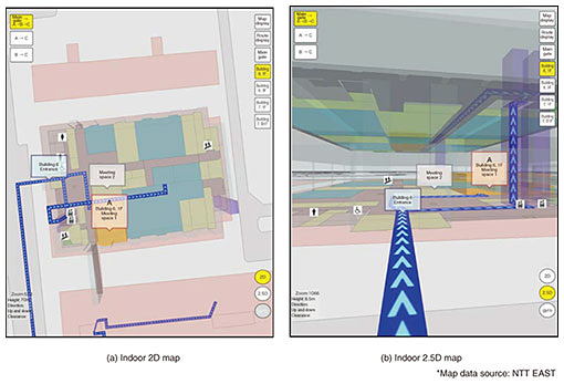
Once the geomagnetic data have been measured, there is no need to remeasure the data as long as there are no major structural changes such as large-scale construction, and this feature enables stable positioning on a continuous basis. At Narita Airport up until now, indoor maps and a geomagnetic-positioning environment were created in a series of development phases. In other words, the foundation of highly accurate indoor position information was laid. By utilizing this foundation, various services can be developed in the future. In addition to providing infotouch and NariNAVI, we will continue to collaborate with NAA to further improve services at airports by, for example, analyzing the behavioral history of users from log information, improving the work processes of airport staff, and managing goods such as luggage carts and strollers. Also, from a user’s viewpoint, expanding the area in which users can be guided indoors would enable the same service to be received anywhere, leading to improved user convenience. NTT DATA intends to roll out this service at other airports and public transportation facilities in the future. 2.2 Advanced 2.5D-map platform technologyAt NTT Service Evolution Laboratories, we have been carrying out research and development aiming to achieve navigation services that provide safe and convenient support for movement of a diverse group of people including those using wheelchairs and strollers, elderly people, and international visitors to Japan. That research resulted in the development of 2.5D-map platform technology, which enables seamless transmission and display of outdoor and indoor hierarchical maps (i.e., planar maps with floor and height information). Unlike automobiles, which basically move in a planar manner, people move in a stereoscopic manner. Movements of people include coming and going indoors and outdoors as well as movements up and down stairs and elevators. With conventional map services, this situation was handled by switching overlapping planar (2D) maps; however, with that approach, it is difficult to see one’s present location and a destination on different floors from a bird’s-eye view, and the guided route is cut off at each level, making it difficult to understand the route intuitively. With these circumstances in mind, we simply added height information (i.e., the number of levels in each floor, ceiling height, etc.) as an extra half dimension (+ 0.5D) to indoor 2D floor maps aligned on a conventional outdoor 2D map to create a way to automatically generate, transmit, and present simple stereoscopic maps, referred to as 2.5D maps (Fig. 3). Changing the map to a stereoscopic representation from 2D to 2.5D, as mentioned previously, makes it possible to view the positional relationships between different levels connected by staircases and elevators, and a guided route can be confirmed at a glance at any time. As a result, the user can see the route clearly ahead of time and, for example, decide whether to go left or right before going up the stairs. It is also possible to display walls or floors transparently, so the user can foresee things that cannot be seen in the real world.
Although it does not express images as elaborately or realistically as a 3D map does, it reduces the time and cost of creating maps by utilizing existing planar maps and indoor floor maps, and the amount of data read by the user terminal and its processing load can also be curtailed. This makes it possible to provide services on a web-browser basis regardless of whether a personal computer or mobile device is being used. In fact, the maps displayed on infotouch are used as a common mechanism for map display on both the application and browser versions of NariNAVI. At NTT Service Evolution Laboratories, we have been working on new research and development while receiving feedback on demonstration tests conducted with the Ministry of Land, Infrastructure, Transport and Tourism since 2016, joint demonstrations with private companies, and commercial introduction of the technologies described in this report. For example, creating indoor 2D maps (which are the source of the 2.5D maps) currently requires a lot of manual labor, so we are studying whether it is possible to automatically generate 2.5D maps with existing data used by building-design systems. Since economization is considered to be one of the key objectives when rolling out technology, we hope to increase the efficiency of map-production work as much as possible by using technology and to improve indoor maps at low cost and in a short period of time. Moreover, regarding efforts concerning the ease of understanding the navigation while making maximum use of 2.5D map data, we are also studying guidance methods that do not rely on visual representations (such as maps) for those who are not good at reading maps. Trademark notesAll brand names, product names, and company/organization names that appear in this article are trademarks or registered trademarks of their respective owners. |
||