 |
|||||
|
|
|||||
       |
Feature Articles: NTT Group’s Initiatives for Creating New Value in the Food and Agriculture Sector Vol. 20, No. 6, pp. 26–28, June 2022. https://doi.org/10.53829/ntr202206fa4 Data-driven Soil Cultivation Promoted by NTT DATAAbstractTo promote soil cultivation, we at NTT DATA are using information and communication technology to collect soil-diagnosis data and information on farming operations throughout Japan and compile a database of that information. This database will enable data-driven initiatives in the domain that has relied on past experience and intuition of farmers. The data in the database are normalized by conducting soil analysis using a nationally standardized method that makes it possible to understand not only the characteristics of individual fields but also regional characteristics. We have also developed and are testing a technology for measuring soil composition from satellite images as a means of reducing the time and labor required to collect soil samples for soil diagnosis. Keywords: data-driven, soil cultivation, satellite image analysis
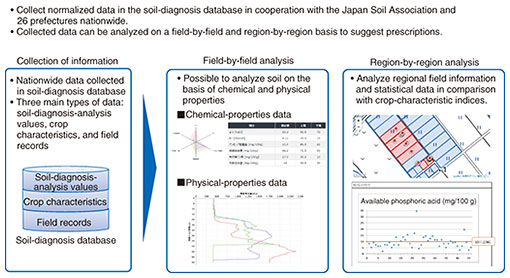
1. Soil cultivation using ICTBecause the amount of compost applied to rice paddies in Japan continues to decline and other issues, degradation of farmland soil has become an issue. Therefore, it is important to strengthen efforts to cultivate soil to improve crop yields by continuously implementing the following cycle: assessing the soil condition through soil diagnosis, planning farming operations in accordance with the assessed soil condition, implementing the planned operations, and verifying the yields. However, soil diagnosis, which should be conducted first, is only applied to certain fields, and farming plans for most fields are prepared according to the experience and intuition of farmers. In response to this situation, the initiative described in this article used information and communication technology (ICT) to collect and compile a database of soil-diagnosis data and farming-operation information throughout Japan. The collected data can be analyzed by taking regional and crop characteristics into account, so farming operations can be suggested in accordance with the analysis results. Therefore, the use of ICT will enable data-driven initiatives in the domain that has relied on past experience and intuition of farmers. 2. Nationwide data collection and use of the dataWhen building a database, it is necessary to ensure data reliability. Soil diagnosis, which is a means of understanding the current status of soil cultivation, has been conducted by local soil-analysis laboratories in each region; therefore, analysis items have not been standardized and cannot be normalized by simply collecting data. To address this issue, NTT DATA, in cooperation with the Japan Soil Association and organizations in 26 prefectures across Japan, established the Soil Diagnosis Database Construction and Promotion Council. As a result of the council’s efforts to collect soil data from across the country using a unified method and consolidate soil-analysis laboratories, it is possible to uniformly handle soil-diagnosis data and analysis values across the country. In addition to soil-diagnosis data, information such as soil physical data, field yields, and farm work carried out can be collected as field records in a manner that allows the field conditions to be understood more clearly. The soil-diagnosis database enables various analyses based on the collected data. For example, when soil diagnosis is conducted for a farm field, the analysis values can be automatically compared with multiple indices—defined by the council—in accordance with crop type so that issues in the field can be identified without relying on the experience and intuition of the farmer. By analyzing statistical information on regions and crop types, it is possible to (i) determine whether soil conditions are good or bad by taking regional characteristics into account and (ii) understand not only the characteristics of individual fields but also those of the region the regional organization of the council is in charge of. In 2021, we collected soil data from approximately 4000 sites nationwide and returned the results of analysis as prescriptions to the farmers and regional organizations that provided us with the soil data. We will continue promoting this initiative and rolling it out nationwide (Fig. 1).
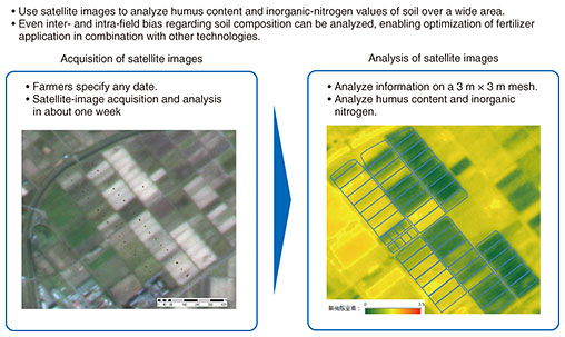
3. Soil diagnosis using satellite imagesThe first step in soil cultivation is to assess the soil condition through soil diagnosis. This soil diagnosis requires a series of tasks that include collecting soil samples from the field, drying them, and sending them to an analytical laboratory. These tasks are labor-intensive, and during busy seasons, the analytical laboratory may require a long time to conduct the analysis, and the results may not be ready in time for the next planting. Even in our efforts to create data-driven soil cultivation, the large amount of time and effort required for soil diagnosis was problematic, so the number of diagnoses did not increase. Accordingly, NTT DATA developed a technology for measuring soil composition from satellite images by using satellite-image analysis technology accumulated through the development and sale of the AW3D*. This technology uses satellite images acquired about once every three days, which makes it possible to acquire and analyze images at appropriate times in accordance with the farming conditions in the field. The analysis currently takes about a week for two component values, namely, humus content and inorganic nitrogen, on a 3 m × 3 m mesh. Using this technology makes it possible to easily obtain the composition values for any field in Japan. Because information is acquired over a wide area, intra- and inter-fields bias regarding soil composition can also be analyzed, which makes it possible to optimize fertilizer application in combination with other technologies such as variable fertilizer application. In 2021, we conducted demonstration tests of this technology in three fields in Miyagi and Niigata prefectures, and we hope to contribute to the promotion of data-driven soil cultivation as we expand the geographical area in which it is tested (Fig. 2).
Authors (from left): Kazuya Yamane, Deputy Manager, Food and Agriculture Business Planning Group, Digital Business Promotion Department, NTT DATA Corporation; and Tomoo Oozeki, Senior Specialist, Food and Agriculture Business Planning Group, Digital Business Promotion Department, NTT DATA Corporation |
||||