 |
|||||
|
|
|||||
       |
Feature Articles: Smart Infrastructure Facility Management Vol. 19, No. 1, pp. 62–67, Jan. 2021. https://doi.org/10.53829/ntr202101fa10 Triple I+P: A GIS Platform for Advanced Geospatial Data ManagementAbstractNTT Infrastructure Network Corporation (NTT InfraNet) centrally manages an enormous amount of telecommunication infrastructure owned by the NTT Group. Accordingly, we have developed proprietary middleware that controls various open-source software for managing the location and attribute information about infrastructure facilities and built a geographic information system platform called Triple I+P (Infrastructure, IT, Innovation Platform). Triple I+P enables users to freely set, for example, drawing settings, data input and output, and combinations of databases and tables without having to carry out programming. By constructing and using a facility database based on Triple I+P, we are promoting digital transformation of facility-management operations inside and outside the company. This article introduces technologies for supporting Triple I+P and some of its use cases. Keywords: GIS platform, digital transformation, open source software
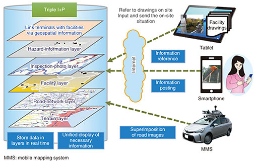
1. GIS platformA geographic information system (GIS) comprehensively manages, processes, and visualizes data related to location information (geospatial information) in a manner that enables advanced analysis and quick decisions. As shown in Fig. 1, each type of information is stored on a separate layer, and the various types of information are superimposed and displayed geographically in a unified manner by using geospatial information as a key. It is possible to obtain a bird’s-eye view of the information, which will contribute to improving operational efficiency, promoting business collaboration, and speeding up the provision of information.
NTT Infrastructure Network Corporation (NTT InfraNet) has developed a GIS platform called Triple I+P (Infrastructure, IT, Innovation, Platform) for managing facilities by integrating information on NTT Group’s infrastructure facilities and external public data. 2. Features of Triple I+PThe features and unique functions of the software configuration of Triple I+P are introduced as follows. 2.1 Adoption of open-source modelThis platform extends the open-source model and is based on core software that controls a large number of open-source-software (OSS) programs. As a GIS environment, we can benefit from using OSS, which is used by an overwhelming majority of users and where the latest technology is constantly incorporated. Using OSS also makes it possible to unlock hidden parts of the databases and avoid vendor lock-in. 2.2 Degrees of freedom by non-programmingManagement of telecommunication facilities requires multiple geospatial calculations for route management, such as extracting facilities around a route. Triple I+P enables attribute search and geospatial-distribution visualization combining various conditions, such as and/or/ = /not =/ ≥ / ≤, for related data. In addition to these degrees of freedom in searching, multiple degrees of freedom in geometric drawing and database definition are also provided (Fig. 2).
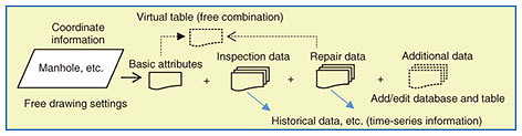
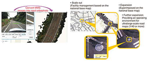
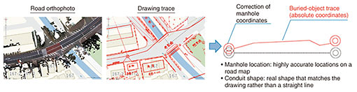
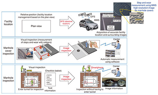
Regarding the degrees of freedom of a database, functions such as (i) combining multiple databases without programming and (ii) adding multiple tables to a basic table for managing coordinates—based on arbitrary key information specified by the user without writing SQL (Structured Query Language)—are available. Therefore, time-series management of facility inspections and repair history are possible. It is also possible to virtually treat different independent databases as one database, aggregate and search data under various conditions, and add attribute information without modifying the table in which basic information is stored. For example, even if the data related to manholes exist independently in a fixed-asset database, inspection/repair database, database of facilities installed in public geospaces, or other databases, it is possible to specify conditions across databases without physically merging each database and search for manholes that match those conditions. Moreover, when historical data concerning inspections and repairs related to manholes are added, the data can be added without duplicating the basic data, so time-series management is possible without changing the base data. 2.3 Incorporation of external informationTriple I+P has functions for supporting standard protocols for sending and receiving geospatial data and multiple external data-exchange formats (e.g., Shape, WMS (Web Map Service), and KML (Keyhole Markup Language)) as well as for geocoding (i.e., converting a place name and address into its latitude and longitude coordinates) even in arbitrary-format data. Data can therefore be acquired from various external geospatial databases in real time, processed in an easy-to-use manner, and used. For example, original data possessed by the Japan Meteorological Agency, such as earthquake and rainfall information, are acquired and processed in real time, damage to facilities is predicted, facilities to be inspected are selected, and damage to those facilities is predicted several hours ahead. Moreover, information disclosed by local government and information disclosed temporarily is acquired in real time by designating it as acquisition source by users. 3. Use cases3.1 Application to facility managementThus far, we have managed a huge amount of infrastructure facilities using paper drawings. Using the advanced display, search function, external-data aggregation function, and three-dimensional (3D)-measurement function of Triple I+P makes it possible to manage facility data collectively and use the data for digital transformation of facility-management operations. (1) Absolute-coordinate conversion of facility-record drawings by using 3D-measurement technology Improving the efficiency of facility-management operations necessitates accurate location information, that is, technology to acquire absolute coordinates with high accuracy is essential. If an orthophotograph (road orthophoto) obtained through the orthographic-projection conversion of a frontal stereo image captured using our mobile mapping system (MMS) [1] is spread on a national base map, it is possible to obtain a live-action road map with absolute location accuracy. This road map corresponds to an ultralarge-scale drawing with a scale of 1/40 or more and is handled using the large-scale-display function of Triple I+P (Fig. 3). By superimposing a facility-record drawing in portable document format (PDF), which is converted from an image of a paper drawing, on this road map and digitally tracing an underground route on the drawing, it is possible to impose absolute coordinates on the drawing and digitize the underground facility (Fig. 4). By importing the incidental information about facilities recorded on the paper drawing as attribute data and using that information and the manhole positional coordinates obtained by running the MMS, vertical profiles and cross sections of the manhole can be automatically generated.
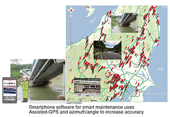
(2) Promotion of smart maintenance through comprehensive reform of facility-inspection operations There are about 690,000 manholes owned by the NTT Group throughout Japan, and a large amount of labor and cost is required for inspecting them; however, 3D measurement technology, such as MMS, has made it possible to determine the absolute coordinates of individual manholes (upper part of Fig. 5). Therefore, by only holding a smartphone over a facility on site, the facility name is displayed on the smartphone. The Global Positioning System (GPS) coordinates of the smartphone are then processed by software for high-precision positioning, and when a photo at the spot is taken, the displayed facility name is affixed to the photo and GPS coordinates and then sent to the center. At the center, information sent from various locations will pop up on the map on the Triple I+P.
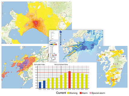
These basic functions are used for inspecting facilities and investigating their failures in the event of a disaster, greatly reducing on-site operations (middle and bottom of Fig. 5). This way of linking geospatial information between the 3D database and on-site information devices makes smart maintenance possible. 3.2 Application for disaster countermeasuresTriple I+P is a platform that flexibly supports tablet functions and functions for receiving photos taken with smartphones in addition to basic functions such as superimposing, searching, and extracting various types of information. Taking advantage of these features, we can effectively apply Triple I+P for countermeasures against earthquakes and heavy rainfall. By mashing up the facility information stored in the database, information collected by NTT InfraNet and information published by government agencies, local governments, and other companies in the geospatial space, it is possible to determine quantitatively and intuitively the area and quantity of the damaged facility, and that information can be used for tasks such as quickly establishing facility-restoration plans, efficiently inspecting facilities, and managing the progress of facility repairs. The main disaster-related information that can be superimposed on a map on Triple I+P is shown in Fig. 6. These sources of information are provided regularly by government agencies in the event of a disaster; however, they cannot be deployed in geospatial space as is. Accordingly, the original information is imported, processed into a mesh, converted into a form that can be handled in geospatial space, and automatically reflected onto Triple I+P.
Triple I+P is equipped with functions for linking with on-site information such as tablet functions and a function for receiving smartphone photos. Since Triple I+P is compatible with tablets, tablets can be used to remotely access Triple I+P from the disaster site and check a multitude of mashed up information. Since Triple I+P can receive photos of the disaster situation taken with a smartphone via the Internet, it is possible to understand the situation at the disaster site in real time from the office of the disaster-countermeasures headquarters. A screenshot of the Triple I+P display for checking the location and status of a disaster is shown in Fig. 7.
4. Future initiativesTriple I+P will continue to evolve by expanding its functions into a platform for advanced facility management using a large-scale database and various applications. We will promote further automation by making full use of technologies such as artificial intelligence (AI), augmented reality, and virtual reality in conjunction with advanced database management. We will also develop technology for automatically determining the degree of deterioration of facilities by AI processing of photographs taken during inspections. Reference
Authors (from left): Chie Kamachi, Engineer, DX Promotion Headquarters, NTT InfraNet; Makoto Ise, Manager, DX Promotion Headquarters, NTT InfraNet; Hirotaka Yoshida, Senior Manager, DX Promotion Headquarters, NTT InfraNet; and Toshihiko Sekiguchi, Manager, DX Promotion Headquarters, NTT InfraNet |
||||